Santorini Seismic Activity: A Scientist's Perspective On The Evolving Situation

Table of Contents
Geological Setting and Tectonic Processes
The Santorini Volcanic Complex
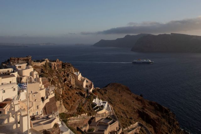
Santorini's dramatic landscape is a direct result of its volcanic history. The island is part of the South Aegean Volcanic Arc, a region of intense geological activity shaped by the convergence of the African and Eurasian tectonic plates. The iconic Santorini caldera, a vast underwater crater, is a testament to the island's most famous eruption – the Minoan eruption, which occurred around 1600 BC and dramatically reshaped the landscape. This cataclysmic event left behind a caldera complex encompassing several volcanic centers, including Nea Kameni and Palea Kameni, which continue to exhibit signs of activity.
- Plate Tectonics: The African plate subducts beneath the Eurasian plate, creating a volcanic arc and significant seismic activity in the region. This subduction process generates immense pressure and heat, leading to magma generation and subsequent eruptions.
- Fault Lines: Santorini is crisscrossed by numerous fault lines, fractures in the Earth's crust that readily facilitate the movement of tectonic plates. These faults are the primary pathways for the release of built-up stress, resulting in earthquakes of varying magnitudes.
- Magma Chambers: Beneath Santorini lies a complex network of magma chambers, reservoirs of molten rock. The pressure exerted by these chambers plays a crucial role in triggering both volcanic eruptions and seismic events. Changes in magma chamber pressure are closely monitored as indicators of potential volcanic unrest.
Monitoring Santorini Seismic Activity
Seismic Monitoring Networks
Continuous monitoring of Santorini seismic activity is essential for assessing volcanic hazards and mitigating potential risks. A sophisticated network of seismic stations, utilizing highly sensitive seismometers, strategically positioned around the island and in the surrounding sea, continuously records ground motion. These data are supplemented by GPS monitoring, which measures subtle ground deformation, providing additional insights into subsurface processes. Organizations like the National Observatory of Athens and the Institute of Geodynamics play crucial roles in collecting and analyzing this data.
- Data Collection and Analysis: Seismometers detect even the slightest vibrations in the ground, providing detailed information on earthquake location, magnitude, and depth. This data is transmitted in real-time to monitoring centers for immediate analysis.
- Earthquake Early Warning Systems: Real-time monitoring is vital for developing effective early warning systems. By detecting the initial seismic waves, scientists can potentially provide crucial seconds or minutes of warning before stronger shaking arrives, allowing for timely evacuation and mitigation efforts.
- Accuracy and Limitations: While monitoring techniques have significantly advanced, accurately predicting the timing and magnitude of future eruptions or significant seismic events remains challenging. Continuous improvement and innovation in monitoring technologies are crucial to enhance prediction capabilities.
Recent Seismic Activity and Trends
Analysis of Recent Earthquakes
Santorini experiences frequent, albeit mostly minor, seismic events. Analyzing the frequency, magnitude, location, and depth of these earthquakes is crucial for understanding the overall volcanic and tectonic activity. Recent years have witnessed periods of increased seismic activity, often characterized by seismic swarms – clusters of numerous earthquakes occurring within a short time span.
- Trends and Patterns: Careful analysis of seismic data reveals patterns that can indicate changes in the underlying magmatic system. For example, an increase in the frequency and magnitude of earthquakes, coupled with ground deformation, might suggest an escalation of volcanic unrest.
- Significance of Events: Even relatively small earthquakes can be significant indicators of ongoing processes within the volcanic system. They provide valuable information for refining models and improving hazard assessment techniques.
- Volcanic Gas and Ground Deformation: Closely monitoring changes in volcanic gas emissions (e.g., sulfur dioxide) and ground deformation (e.g., inflation or deflation of the volcanic edifice) alongside seismic activity provides a more comprehensive picture of the evolving situation.
Potential Hazards and Risk Assessment
Assessing Volcanic and Seismic Risks
Santorini seismic activity presents several potential hazards. Earthquakes, even moderate ones, can cause damage to infrastructure and trigger landslides. Furthermore, a large-scale eruption or a significant submarine earthquake could generate a destructive tsunami, posing a severe threat to coastal communities.
- Hazard Assessment Methods: Scientists employ a variety of methods, including probabilistic hazard assessments, to estimate the likelihood and potential impact of various hazards. These assessments integrate geological data, seismic monitoring information, and historical records.
- Impact on Infrastructure and Population: The dense population and critical infrastructure on Santorini make the island vulnerable to the impact of earthquakes and tsunamis. Detailed risk assessments are essential for prioritizing mitigation strategies.
- Emergency Preparedness: Comprehensive evacuation plans and preparedness measures are crucial. Regular drills and public awareness campaigns are vital to ensure the safety of the island's residents and visitors.
Conclusion
Understanding Santorini seismic activity is an ongoing scientific endeavor. Continuous monitoring, advanced data analysis, and improved hazard assessment techniques are crucial for enhancing our prediction capabilities and mitigating potential risks. While the exact timing and nature of future seismic events remain uncertain, ongoing research and international collaboration ensure a proactive approach to managing the risks associated with this active volcanic system. Stay updated on Santorini seismic activity through reliable sources like the National Observatory of Athens and the Institute of Geodynamics. Learn more about Santorini's seismic and volcanic risks to ensure your safety and contribute to community preparedness. Understanding the evolving situation of Santorini seismic activity is vital for responsible tourism and informed decision-making.

 Vente Des Vins De Nuits Saint Georges Une Matinee Avec Candeloro Et Ladesou
 The 1 Debt Tom Cruises Unfulfilled Obligation To Tom Hanks
 Lowry Makes A Run At The Valspar Championship
 Increased Q1 Profit And Dividend Announcement From Telus
 Tom Cruises Unique Post Birth Gesture For Suri Cruise
