The Yellowstone Magma Reservoir: A Study Of Volcanic Activity And Risk Assessment

Table of Contents
Geological Formation and Characteristics of the Yellowstone Magma Reservoir
The Yellowstone Hotspot Track
The Yellowstone supervolcano is a product of the Yellowstone hotspot, a plume of unusually hot mantle material rising from deep within the Earth's interior. The hotspot theory explains the formation of the Yellowstone caldera and the Snake River Plain, a long chain of volcanic features stretching across Idaho.
- Age of the hotspot: The Yellowstone hotspot is estimated to be millions of years old, with evidence suggesting its existence for at least 16 million years.
- Movement of the North American plate: As the North American plate moves slowly westward, the stationary hotspot creates a trail of volcanic activity, forming the Snake River Plain.
- Evidence of past eruptions along the track: The Snake River Plain provides a geological record of past eruptions, revealing the hotspot's long history of volcanic activity, with massive caldera-forming eruptions occurring at various points along the track.
Structure and Composition of the Magma Chamber
The Yellowstone Magma Reservoir is a complex system, not a single, well-defined chamber. It's believed to be a partially molten zone, extending several kilometers beneath the surface, with pockets of magma at varying depths and compositions.
- Seismic imaging techniques: Scientists use various techniques, including seismic tomography and earthquake location analysis, to map the subsurface structure and estimate the size and shape of the magma reservoir.
- Estimations of magma volume: While precise estimations are challenging, studies suggest a significant volume of molten and partially molten rock exists beneath Yellowstone. However, only a small fraction of this is readily eruptible magma.
- Chemical analysis of volcanic rocks: Analysis of volcanic rocks provides information on the chemical composition of the magma, helping scientists understand its origin and potential eruptive behavior.
Geothermal Features and Their Significance
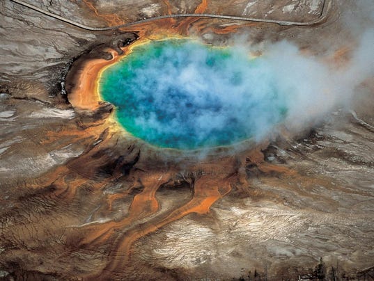
Yellowstone National Park is renowned for its abundant geothermal features, a direct manifestation of the underlying magmatic activity. These features serve as crucial indicators of the reservoir's state.
- Examples of notable geothermal features: Old Faithful geyser, the Grand Prismatic Spring, and numerous other hot springs and fumaroles provide visual evidence of the heat flow from the magma reservoir.
- Their connection to the magma reservoir: The heat driving these geothermal features originates from the magma reservoir, making them invaluable tools for monitoring its activity.
- Monitoring techniques: Scientists monitor temperature changes, gas emissions, and ground deformation around geothermal features to detect subtle shifts in the magmatic system.
Monitoring Volcanic Activity in the Yellowstone Magma Reservoir
Continuous monitoring of the Yellowstone Magma Reservoir is crucial for assessing the risks of future eruptions. A multi-faceted approach employing various techniques is employed.
Seismic Monitoring
A dense network of seismometers constantly monitors seismic activity in the Yellowstone region. This data helps detect earthquakes and tremors, which are often associated with magma movement.
- Types of earthquakes: Both tectonic and volcanic earthquakes are detected, with the latter often indicating changes in the magmatic system's pressure or movement.
- Frequency of seismic events: The frequency and intensity of seismic events provide valuable insights into the overall activity level of the reservoir.
- Interpretation of seismic data: Sophisticated analysis techniques are used to locate earthquakes precisely, determine their magnitude, and infer the processes responsible for their occurrence.
Ground Deformation Measurement
GPS and InSAR (Interferometric Synthetic Aperture Radar) are used to measure changes in the ground surface. These techniques can detect even subtle uplift or subsidence, often associated with magma movement beneath the surface.
- Detection of uplift and subsidence: Uplift can indicate magma intrusion, while subsidence can reflect deflation or changes in pressure within the reservoir.
- Correlation with magma movement: Changes in ground deformation are carefully correlated with other monitoring data, such as seismic activity and gas emissions, to build a comprehensive picture of the reservoir's dynamics.
- Interpretation of deformation data: Advanced geodetic techniques are employed to interpret the data accurately and understand the processes driving ground deformation.
Gas Emission Monitoring
Monitoring the release of gases such as carbon dioxide (CO2) and sulfur dioxide (SO2) provides crucial insights into the magmatic system. Changes in gas flux can indicate increased volcanic activity.
- Methods of gas sampling and analysis: Scientists employ various techniques, including direct sampling of gas vents and remote sensing methods, to measure gas emissions.
- Interpretation of gas flux changes: Increases in gas fluxes can indicate changes in the pressure or composition of the magma reservoir.
- Correlation with other monitoring data: Gas emission data are integrated with other monitoring parameters to provide a holistic view of the volcanic system's state.
Risk Assessment and Mitigation Strategies for the Yellowstone Magma Reservoir
Assessing the risk associated with the Yellowstone Magma Reservoir involves considering the probability of different eruption scenarios and their potential impacts.
Probability of Eruption
While a super-eruption is possible, it's considered a low-probability event. Smaller eruptions, however, are more likely.
- Time scales involved: The time scales for various eruption scenarios range from decades to millennia. Predicting the precise timing of future eruptions remains a significant challenge.
- Different eruption scenarios: Scientists model various scenarios, from relatively small lava flows to larger explosive eruptions, to assess their potential impacts.
- Uncertainties in prediction models: The complexity of the Yellowstone Magma Reservoir makes precise eruption forecasting extremely challenging. Continuous monitoring and improved models are vital.
Potential Impacts of an Eruption
The potential impacts of a Yellowstone eruption would depend on its size and style. Effects could range from localized impacts to widespread regional and even global consequences.
- Geographic reach of potential impacts: The reach of ashfall, pyroclastic flows, and lahars (volcanic mudflows) would depend on the eruption's magnitude and wind patterns.
- Effects on human populations and infrastructure: The area surrounding Yellowstone would be significantly affected, with potential for widespread disruption to infrastructure and displacement of populations.
- Long-term environmental consequences: A large eruption could have significant long-term environmental impacts, influencing regional and global climate patterns.
Emergency Preparedness and Response Planning
Mitigation strategies focus on enhancing preparedness and response capabilities. This involves a combination of early warning systems, evacuation plans, and public education.
- Early warning systems: Improved monitoring and data analysis help provide earlier warnings of potential eruptions.
- Evacuation plans: Detailed plans are in place for evacuating populations in the event of an eruption.
- Community education and outreach: Public education programs ensure communities understand the risks and are prepared to respond appropriately.
Conclusion
The Yellowstone Magma Reservoir represents a significant geological wonder and a potential source of considerable risk. Continuous monitoring and research are crucial for improving our understanding of its volcanic activity and developing effective mitigation strategies. By closely observing seismic activity, ground deformation, and gas emissions, scientists can refine their risk assessments and contribute to better preparedness for future events. Further research on the Yellowstone Magma Reservoir is essential for minimizing the potential impacts of future eruptions and ensuring public safety. Learn more about the ongoing research and monitoring efforts related to the Yellowstone Magma Reservoir to stay informed and contribute to a safer future.

Featured Posts
-
 Sarah Ferguson Offered Ppe Help During Early Covid Lockdown Inquiry Details
May 27, 2025
 -
 Osimhen To Manchester United Transfer Speculation And Reality
May 27, 2025
 -
 Katsina Attack Nine Feared Dead Including A Policeman
May 27, 2025
 -
 Navigating Intimacy The Complexities Of The Sex Lives Of College Girls
May 27, 2025
 -
 Damkarmat Bandar Lampung 334 Penyelamatan Non Kebakaran Hingga Awal Mei 2025
May 27, 2025
